Imagine stepping out your door for coffee, a riverfront walk, and dinner with friends, all without moving your car. If you are eyeing Downtown Chattanooga, that car-light lifestyle is closer than you might think. In this guide, you will see how walkable living works here, from riverfront paths and the free shuttle to micro-areas and housing types that make daily life easier on foot. You will also get a quick checklist to test any address. Let’s dive in.
What walkable living means downtown
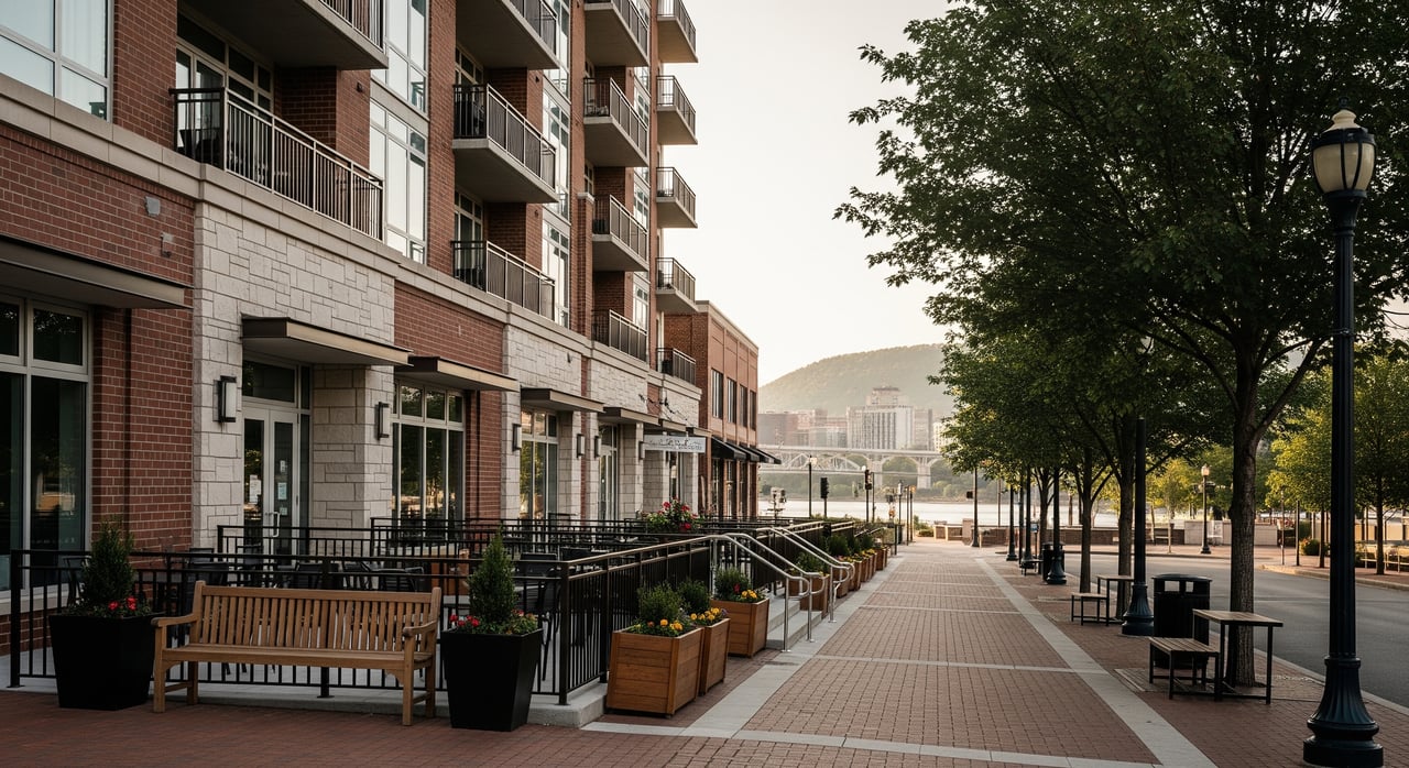
Walkable living means you can meet most daily needs on foot, by bike, or with a short transit ride. Downtown Chattanooga has a compact core with restaurants, parks, and attractions clustered along the river and main streets. Many central addresses typically score in the high 60s to 80s on Walk Score, though it varies block by block. For any building you are considering, check the specific address on Walk Score to see nearby amenities and transit options.
Core walking and bike routes
Riverwalk and riverfront plazas
The Tennessee Riverwalk is a paved, mostly flat spine along the river that ties together parks, piers, and destinations for walkers and cyclists. It stretches for roughly 13 miles through the city system, which turns a scenic stroll into a practical connection between neighborhoods and the downtown core. You can explore the route and key access points on TrailLink’s Tennessee Riverwalk page.
Sidewalks and wayfinding
Downtown offers continuous sidewalks, a compact street grid, and pedestrian wayfinding signs that make it simple to navigate between the Aquarium, Market and Broad Streets, and Ross’s Landing. The civic group River City Company highlights these assets and posts updates on downtown mobility and parking. Review their overview of getting around Downtown Chattanooga to understand how paths and plazas connect.
Walnut Street Bridge update and detours
The Walnut Street Bridge is an iconic pedestrian link to Northshore and Coolidge Park. It entered an 18‑month renovation on March 17, 2025. During this time, the city has posted pedestrian detours using Veterans Bridge and Market Street Bridge, along with added wayfinding and transit adjustments to keep access open. For current detours and timing, check the City of Chattanooga’s project page.
Transit and micro‑mobility
Free CARTA Downtown Electric Shuttle
CARTA operates the free Downtown Electric Shuttle that runs between the Chattanooga Choo Choo on the south end and the Tennessee Aquarium on the riverfront. It is designed for short downtown trips, runs frequently, and is wheelchair accessible. You can confirm stops, frequencies, and service notices on CARTA’s Downtown Shuttle route page.
Bike Chattanooga docks and e‑bikes
Bike Chattanooga offers station-based pedal bikes and e‑bikes with numerous docks around the core. E‑bikes make hills and slightly longer rides more comfortable, which expands what feels “walkable.” Check the dock map, real-time availability, and pricing on the Bike Chattanooga site.
Parking and event trade-offs
Downtown has meters and garages, though patterns change during major events like Riverbend and sports weekends. Many car-light residents keep a car for occasional trips and use paid parking or ride-hailing when crowds peak. To plan around events and meter rules, use River City Company’s guide to getting around and parking.
Where walkable life clusters
Riverfront core
The riverfront core around the Tennessee Aquarium, Ross’s Landing, and Broad Street concentrates daytime attractions, restaurants, and plazas. Condos and newer apartment buildings place you steps from dining, the Riverwalk, and shuttle stops. If you want a lively scene with short walks to evening options, this area is a strong fit.
Southside and Warehouse Row
Southside blends loft-style spaces, independent retailers, and popular restaurants along Market Street and Warehouse Row. Many residents walk to cafés and nightlife, then bike or hop on the shuttle for errands a bit farther out. Buildings here often offer smaller footprints with immediate access to services and entertainment.
Bluff View and Arts District
This pocket near the Hunter Museum mixes galleries, cafés, and scenic overlooks with quieter residential streets. You are still within walking distance of cultural spots and the riverfront, but the bluffs introduce hills that can make some walks more strenuous. Many residents use e‑bikes or scooters to smooth out the topography.
Northshore during bridge work
Coolidge Park, Frazier Avenue, and Renaissance Park offer river views, open lawns, and storefronts across the river from downtown. While the Walnut Street Bridge is under renovation, you can reach Northshore using the city’s posted detours via Veterans Bridge and Market Street Bridge. Wayfinding and transit adjustments help maintain access while work continues.
UTC and stadium edges
Around the university and stadiums, you will find compact housing options and quick bus links. These areas are easy to navigate on foot for events and daily routines near campus. For trips outside the core, most residents use CARTA or a car.
Housing types that support a car-light life
Condos and downtown apartments
In the riverfront and core corridors, condos and apartments often deliver the most car-light setup. You are close to restaurants, parks, and shuttle stops, though space and storage can be tighter. Many residents trade larger kitchens or closets for unbeatable convenience.
Loft conversions and studios
In Southside, lofts and studios give you walk-to-dinner living with transit and bikeshare nearby. On-site parking can be limited, so plan for street or garage options when needed. This setup works well if you prefer frequent walking and biking over daily driving.
Townhomes and older single-family options
In parts of the Arts District and Bluff View, townhomes and older single-family homes offer more interior space in a scenic setting. Streets can be steeper, and food or nightlife may sit a bit farther away depending on the block. If you like a quieter vibe with cultural access, this trade-off can be a fit.
A quick checklist to test any address
- Walk Score and nearby amenities: Check the specific address on Walk Score for walk, transit, and bike indicators.
- Bikeshare proximity: Open the Bike Chattanooga map to find the closest dock and confirm e‑bike availability.
- Shuttle and bus stops: Verify stop locations and service notices on CARTA’s Downtown Shuttle route page.
- Riverwalk access: Time a 10 to 15 minute walk to a named park or pier using the Tennessee Riverwalk map.
- Groceries and errands: Use Walk Score’s map to see groceries, pharmacies, and dry cleaners within a 10 to 15 minute walk.
- Terrain and mobility: Test your common routes at typical times. If hills are a factor, consider an e‑bike or scooter and confirm local use rules.
- Events and parking: Before committing, scan downtown event schedules and review parking guidance, including guest options.
Is car-free living realistic downtown?
For many residents, yes for daily life inside the core. Restaurants, parks, and entertainment are typically a short walk, bike ride, or shuttle trip away. Most car-light households still keep access to a car for out-of-town travel, larger grocery runs, or specialized errands. Your exact experience will depend on the block, so always verify with the checklist above.
Ready to find a condo, loft, or townhome that fits how you move? Our team pairs deep local knowledge with a concierge approach to help you compare blocks, weigh trade-offs, and choose with confidence. Start the conversation with the Don Ledford Group and explore the downtown addresses that match your lifestyle.
FAQs
Is Downtown Chattanooga walkable for daily errands?
- Many central addresses in the core are walkable for dining, parks, and entertainment, and you can verify convenience for groceries and services by checking an address on Walk Score.
How does the Walnut Street Bridge closure impact Northshore access?
- The bridge entered an 18‑month renovation on March 17, 2025; use city-posted detours via Veterans Bridge and Market Street Bridge and check the City of Chattanooga’s project page for updates.
Is the CARTA Downtown Shuttle free and accessible?
- Yes, the Downtown Electric Shuttle is free, designed for short trips between the Choo Choo and the Aquarium, and is wheelchair accessible; confirm hours on CARTA’s route page.
Where can you bike safely by the river?
- The paved Tennessee Riverwalk connects parks and piers along a mostly flat route, and you can review access points and distance on TrailLink’s Riverwalk page.
Do you need a car if you live in a Southside loft?
- Many residents walk to dining and use the free shuttle or Bike Chattanooga for short trips, then keep access to a car for bigger errands or travel; use Walk Score and the bikeshare map to assess any specific address.